
Wind, constant wind & Trail Provides (D-4)

Finally the hike thru the "real" desert - as I had imagined it - happened today.  No trees at all, only shrubs, cacti, dusty, wide flat vistas and absolutely relentless wind that almost never let up till the late evening.  The wind was so strong in the second half of the day that it even literally pushed me uphill sometimes.  The extra backpack weight seemed like the only thing that kept me from being blown here & there 😄. One good thing about the wind...it made the day seem cooler. And wind/sun way better than wind/rain.

I have been drinking water from 1 liter bottles that are kept in the side pocket of my pack.  Unfortunately they are not easy to access and I have to carry a bottle in my hand when I need to sip it frequently.  This is a pain! So, I had decided to buy a thin tube at the next town in a few days and insert it into the bottle cap to make a flexible straw to make my life easier. However, this afternoon, I came upon the water cache along with a couple of hiker boxes (where hikes leave stuff they don't need and anybody can take those for free) next to it.  And one of the boxes had not one, but two drinking tubes that fit my bottles. Cleaned one up and checked it - it worked! As they say...the Trail Provides 😊
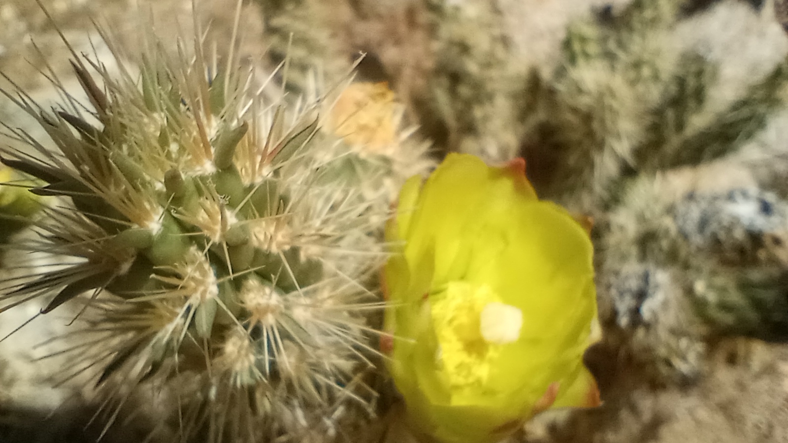
A most welcome water cache at Scissors Crossing, below the highway bridge, with water, chairs, some food, hiker boxes & trash cans

Ta-da!
Trail markers - very well-placed to make sure you don't get lost

Filtering water

Desert blooms:
My tent site:
For my data-minded friends :

Comments

[v] said…
You're totally rebelling against runners. Stopped few 100 metres short of 42.195!

Why why? 🤣
Kavita Nair said…
Raviiiiii 300 freaking mts for a FM! why didnt you? aghhh, i am having a Sheldon brain Itch now! hhahah
Aam Aadmi said…
Enjoyed reading the updates, learning about Trail Magic etc. The pictures are lovely and I am impressed that you got the wifi and power to keep these updates coming.

And, you stopped just short of a FM reminded me of Forrest Gump.
Kanchan said…
Loved the pictures and your experience. Keep going Ravi. I am sure it's tough but tour descriptions make me want to try Long trails
Vipul said…
Great going Ravi, I am just wondering is it you alone throughout the day ? Are there days when you dont see somebody at all ?

Popular posts from this blog

My gear and my tramily (D-97 @ 2148 - Zero day)

Some of you have asked about what gear I am using. Since today is a Zero day (the last Zero day was on D-57) and there is nothing much to report other than the fact that I shipped the last set of resupply boxes to different places in Washington state and ate substantial amounts of food today, I figured I might as well talk about my gear, and also a bit about the other most essential component on the hike - my "tramily" (trail-family).   Tent : 1-person Rainbow Li from Tarptent (bought new). This has worked very well for me and as you know from my earlier posts, Tarptent has given very good customer service too. I haven't had the chance to use the tent in heavy rain or snow (luckily) though and can't comment on it. I use a Tyvek ground sheet (already owned), also from Tarptent. Backpack : Catalyst from ULA (already owned).  I started with Zpack Arc Air Robic 60L (bought new) and used it for 700 miles, but it was not comfortable at...

Monthly Data Update (M-4; Day 91 to 118)

  All data below in italics is for M-1, M-2 & M-3 respectively, for comparison. M-4 is 28 days (all other months were 30 days) Distance traveled on PCT: 702 mi / 1130 km   ( 631 mi / 1015 km; 554 mi / 892 km; 798 mi /1284 km ) Total time: 281 ( 280; 280; 320 ) hours Total ascent:  126,923 ft / 38,686 m ( 117,830 ft/35,915 m; 99,040 ft/30,190 m; 123,951 ft/37,780 m )  Total descent: 128,161 ft / 39,063 m  ( 115,912 ft/35,330 m; 99,730 ft/30,400 m; 123,921 ft/37,771 m ) Highest point: 7174 ft / 2187 m ( 9407 ft/2867 m; 13,120 ft/4000 m; 7580 ft/2310 m ) Average distance/day: 25 mi / 40 km ( 21 mi/34 km; 18.7 mi/30.1 km; 26.6 mi/42.8 km )  Average distance/hiking day: 26 mi / 42 km ( 21.8 mi/35.1 km; 21.3 mi/34.3 km; 26.6 mi/42.8 km ) Average time hiking/day: 10.0 ( 9.3; 9.3;  10.7) hours (incl Nero days) Average pace: 2.6 mph/4.2 kmph ( 2.3 mph/3.6 kmph; 2.0 mph/3.2 kmph; 2.5 mph/4.0 kmph ) Number of Zero days:...

Hiking in Oregon - Lakes Heaven & Mosquito Hell (D-82: 1717.7 - 1742.7, D-83: 1742.7 - 1776.3, D-84: 1776.3 - 1805.8, D-85: 1805.8 - 1839.3 - see note in Data, D-86: 1839.3 - 1869.4, D-87: 1869.4 -1899.1, D-88: 1899.1 - 1930.6, D-89: 1930.6 - 1952.6)

Apologies for the long delay in updating the blog. Cell service has been spotty but more importantly, the days have been long and I just couldn't find the time or energy at the end of the day to write. Oregon is supposed to be relatively flat, at least, when compared to other PCT sections and that is indeed somewhat true. But, it is still a lot of ups and downs and the 30-mile days do take 13+ hours of hiking. Anyway, that's my excuse 🙂. The first couple of days after Ashland were ho-hum and it was just hiking as usual. Got some trail magic from Ron & I tried peanut butter & jelly sandwiches - on Texas Toast thick bread - for the first time in my life (I really don't like peanut butter). Not bad, but not going to be my favorite food anytime soon 😀. Encountered some rocky trail - with really hard black & red volcanic rocks that could be felt through the trail shoes (really wish I had hiking boots instead of trail running shoes). ...